
Predictions of torrential rain across the UK have triggered dozens of flood warnings and the issuing of a “precautionary evacuation notice” in one part of the country.
The Met Office has issued a yellow warning of heavy rain until midnight on Monday covering southern and central Wales and the West Midlands.
Forecasters said around 25mm of rain had already fallen in Pembrokeshire in south-west Wales earlier on Monday, with a further 10 to 15mm set to fall in the evening.
Derbyshire Fire and Rescue Service said that at around 8pm on Monday, firefighters had rescued an adult and a child trapped in a vehicle caught in floodwater in Bretby, near Burton upon Trent.
At around 9pm, crews from North Yorkshire Fire and Rescue Service also came to the aid of a woman in a car stuck in floodwater on Cattal Moor Lane, near York.
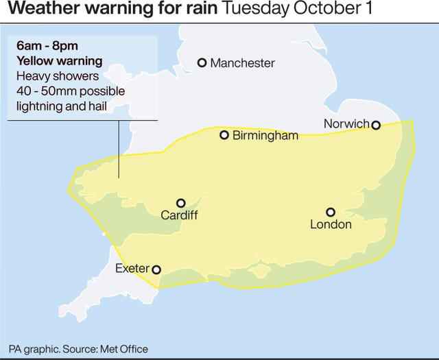
A further Met Office yellow weather warning for heavy showers is in place from 6am to 8pm on Tuesday covering the south of England, South Wales, the Midlands and parts of East Anglia.
Meteorologist Luke Miall said: “We could see some local quite torrential downpours and a risk of surface water flooding.”
He warned that slow moving clouds on Tuesday meant “we could see as much as 40 to 50mm maybe in a couple of hours in some spots”.
As of 8pm on Monday, the Environment Agency had issued 70 flood warnings advising immediate action and 184 flood alerts urging people to prepare for possible flooding, all covering the length and breadth of the country.
In west Norfolk, a “precautionary evacuation notice” has been issued for the coastal areas of Hunstanton, Heacham and Snettisham.
The Environment Agency said a combination of a high tide due at 8.40am on Tuesday and predicted force six north-westerly winds could result in flooding.
High tides and winds tonight has created flood warnings across the South West coastline. Avoid the seafront and check if a flood warning is in place at https://t.co/QdPKdEYx15. pic.twitter.com/9As1r0vmj7
— Environment AgencySW (@EnvAgencySW) September 30, 2019
People are being told to leave caravans and properties in the area between 7am and 10am on Tuesday and not to return until it is safe to do so.
They are also urged to take with them any medication, pets and anything urgent they might need over the next 48 hours.
The public are also being advised to take care along beaches, promenades, coastal footpaths and roads as large waves and sea spray could be dangerous.
In the South West, the Environment Agency also told people to avoid the seafront and check on flood warnings due to forecast high tides and winds.
Natural Resources Wales encouraged drivers to take care on the roads because of the likelihood of surface water flooding on Monday night.
The Met Office warned that on Monday evening homes and businesses could be flooded, with the rainfall also possibly affecting buses, trains and road travel.
This satellite and radar imagery shows the heavy #rain sweeping across England and Wales 🌧️ pic.twitter.com/GLzr7AqOkE
— Met Office (@metoffice) September 30, 2019
On Tuesday it said predicted heavy showers could bring a “small chance of fast-flowing or deep floodwater causing danger to life”.
Earlier on Monday, Gloucestershire Police called off a search after a man, feared to have been swept away by the Severn Bore wave, was located safe and well.
A second call from someone concerned they had seen a person or animal struggling in floodwater was also stood down.
Rain and strong winds may also hit the UK later in the week as the remnants of ex-tropical storm Lorenzo arrive on Friday.
Currently classed as a category 2 hurricane, Lorenzo is due to hit west of the Portuguese Azores islands on Tuesday.
Mr Miall said the storm, becoming an “ex-hurricane”, could track up to the west of the UK on Friday bringing heavy rain and winds of up to 60mph.
He emphasised that there was still “some uncertainty” over the possible course of the storm.


Comments: Our rules
We want our comments to be a lively and valuable part of our community - a place where readers can debate and engage with the most important local issues. The ability to comment on our stories is a privilege, not a right, however, and that privilege may be withdrawn if it is abused or misused.
Please report any comments that break our rules.
Read the rules here